AI in Agriculture: How Farms Use AI, Computer Vision and Drones in 2026
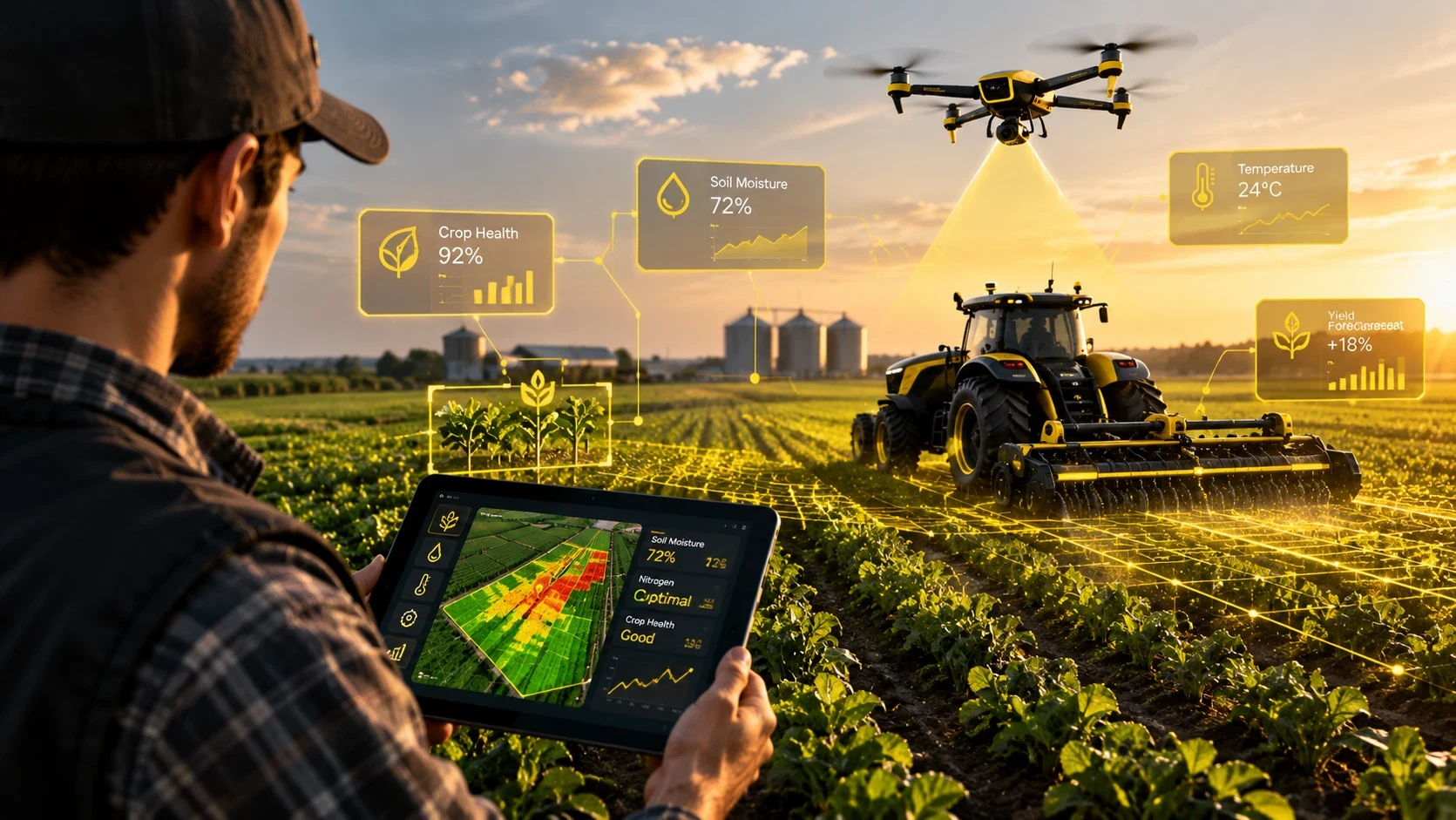
In 2026, “AI in agriculture” is no longer a distant concept. It is visible in the field, in the cockpit, and in the barn. It is a camera mounted on a sprayer boom that recognizes individual weeds and triggers a nozzle to kill them. It is an agricultural drone that maps crop health using multispectral sensors, then returns to spray only the areas that need it. It is a satellite overhead, feeding data into models that help forecast yields. It is a robot picking fruit in an orchard, or a collar on a cow that tracks where it is and how it behaves.
Farmers and agronomists are using these tools to manage inputs more precisely. They are tracking water use, reducing pesticide applications, and monitoring livestock health with sensors that never sleep. The technology is not magic. It relies on specific hardware, established regulations, and algorithms trained on real-world data. This article covers what is actually flying, growing, and working on farms right now, based on the facts available as of October 2026.
Why farming needs AI
The pressure on global agriculture is structural. According to the FAO (2017, “The future of food and agriculture”), by 2050, agriculture will need to produce almost 50% more food, feed, and biofuel than it did in 2012. The world population is projected to reach about 9.73 billion by then. At the same time, the sector is under scrutiny for its resource consumption. The FAO (December 2025 AQUASTAT release) states that agriculture accounts for 72% of global freshwater withdrawals. A 2025 study in PNAS Nexus argued that the widely cited ~70% figure lacks solid empirical support, so it is best read as an approximation. Either way, water is a finite resource that needs to be managed tightly.
Pesticide use remains high. According to FAOSTAT (July 2025), global pesticide use in 2023 was 3.73 million tonnes of active ingredients, about double the 1990 level, or 2.40 kg per hectare of cropland. Precision agriculture offers a way to apply these inputs only where they are needed.
Adoption is uneven. According to the USDA NASS (August 2025), 22% of US farms used precision agriculture practices in 2025, including drones. The gap between large and small farms remains stark. According to the USDA Economic Research Service (2023, survey data 2016–2018), auto-steer was used on 73% of corn acres on the largest farms but only 10% on the smallest (2016), and 68% vs 11% for soybeans (2018). Internet access has improved, with 85% of farms having access according to the same USDA NASS report, but the hardware and software costs still favor larger operations. Services that farms can hire rather than buy, such as drone spraying and satellite mapping, are one way smaller operations get access to the same tools.
Precision spraying: computer vision that sees each weed
Precision spraying is one of the most tangible applications of computer vision in agriculture. Instead of blanketing an entire field with herbicide, the system identifies weeds in real time and treats them individually. This requires a camera system mounted on a sprayer boom or a robot, a machine learning model that distinguishes crop from weed in milliseconds, and a mechanism—usually a nozzle or a laser—that acts only on the detected weed.
John Deere See & Spray is a leading example. According to Deere (November 2025), the system was used on more than 5 million acres in the 2025 season. It cut non-residual herbicide use by nearly 50% on average, saving nearly 31 million gallons of herbicide mix. In January 2026, Deere said the second generation (model-year 2027 sprayers) extends the system to wheat, barley, canola, sugar beets, and peanuts. The technology relies on high-speed image recognition to classify plants as the sprayer moves at typical field speeds.
Greeneye Technology has also demonstrated significant savings. In a University of Nebraska-Lincoln trial reported by the company in 2022, its system used 87% less non-residual herbicide while matching broadcast spraying on broadleaf weed control (96.3%). The cost was $40.60 per acre versus $105.80 for broadcast. Systems like this rely on object detection running in real time, and their results depend on calibration and on how well the model knows local weed species.
Carbon Robotics LaserWeeder G2 takes a different approach. According to the company (February 2025), it kills weeds with lasers at millimetre accuracy, up to twice as fast as the previous model. The company says its machines have treated more than 250,000 acres and eliminated more than 15 billion weeds, and can cut weed-control costs by up to 80%. The laser approach is chemical-free, which appeals to organic and sustainable farms.
Ecorobotix ARA targets individual plants and can cut herbicide, fungicide, and foliar product use by up to 95%. According to the company (reported October 2025), it is sold in more than 20 countries, and the company has raised $150 million. These systems represent a shift from broadcast to targeted application, driven by image segmentation and real-time decision-making.
Agricultural drones
What farm drones do
Agricultural drones in 2026 serve multiple roles. They spray liquids, spread granular fertilizers, seed cover crops, and map fields using multispectral cameras. The mapping role is critical for precision agriculture. Drones capture data that helps farmers understand crop health, water stress, and pest pressure.
The DJI Mavic 3 Multispectral is a common tool for mapping. According to the company, it captures green, red, red-edge, and near-infrared bands for NDVI crop-health maps. It can cover up to 2 square kilometres per flight. This data is processed into maps that highlight areas of stress, allowing farmers to scout specific zones rather than walking entire fields.
For spraying, the DJI Agras T100 is a prominent model. According to the company specs, it has a 100-litre spray tank and a 150-litre spreading tank. These drones use terrain-following flight and RTK (Real-Time Kinematic) positioning to maintain consistent height above the crop, ensuring even application. They are often used for spot spraying based on maps generated by mapping drones or satellites.
How a spray drone job works, step by step
-
Mapping first: The process begins with data. A mapping drone equipped with a multispectral camera flies over the field, or the operator pulls existing satellite imagery. Software analyzes this data to generate a field map, highlighting variations in plant health or weed density. The program then converts these visual patterns into a prescription map, specifying exactly which zones require treatment, how much product each zone needs, and which areas can be skipped entirely.
-
Flight planning: Once the prescription is ready, the operator loads it into the drone’s planning software. They draw the field boundaries and mark known obstacles like power lines, trees, and buildings. The software calculates the flight path, setting the swath width, flight height, and forward speed. This pre-flight calculation ensures the drone covers the area efficiently without hitting obstacles or missing spots.
-
Positioning and terrain following: Precision matters. The drone uses RTK (Real-Time Kinematic) positioning to stay on its planned lines within centimeters. Simultaneously, radar or optical sensors maintain a constant height above the crop surface. This terrain-following capability is critical for uneven ground or slopes, ensuring the spray volume remains consistent regardless of the landscape’s shape.
-
Spraying: The drone executes the flight plan automatically. As the rotors spin, the downwash pushes droplets down through the canopy, reaching the lower leaves where many pests and diseases hide. The pilot monitors the operation from the ground or a nearby station, ready to pause or abort the mission if an unexpected issue arises, such as a bird flock or a sudden gust.
-
Refill and battery swaps: Unlike ground sprayers, which carry large tanks, spray drones have limited payload capacity. This means frequent stops are necessary. A ground crew mixes the next batch of product, refills the tank, and swaps depleted batteries between flights. This logistical loop often dictates the daily workload; the speed of refilling and swapping directly determines how many acres a crew can cover in a day.
-
Records: After the mission, the drone logs detailed data. It records where the product was applied, the exact amount used in each zone, and the flight path taken. These records are essential for compliance with agricultural regulations and for agronomists to measure the results of the application in the following weeks.
When drones make sense
Drones excel in situations where traditional equipment struggles. They are ideal for wet fields where a tractor would get stuck or compact the soil, and for steep or small, irregular fields that are difficult to navigate with large machinery. They also perform well in tall crops where ground equipment might crush the plants, and for precise spot treatments that target specific weed patches rather than blanket-spraying the entire area. Timely application is another key advantage; when ground equipment cannot enter the field due to mud or crop height, drones can still fly and apply treatment when it matters most.
However, drones are not always the right tool. For very large, open, and flat fields, big ground sprayers or manned aircraft often cover ground faster with fewer refills. If the field is uniform and accessible, the efficiency of a large tractor may outweigh the precision of a drone. The choice depends on field size, terrain, and the urgency of the application.
How most farms actually use drones
Many farms do not buy their own spray drones. Instead, they hire a licensed spray-drone service. This approach avoids the cost of purchasing equipment, hiring additional pilots, and managing the logistics of battery charging and tank cleaning. When hiring a provider, farmers should ask for proof of FAA Part 137 certification and any necessary exemptions. It is also wise to verify insurance coverage and pesticide applicator licensing, where required. Ask about their drift management practices and wind limits, as these factors significantly affect application quality. Finally, request a sample of their application records to ensure they keep detailed, accurate data for future reference.
How many agricultural drones are flying
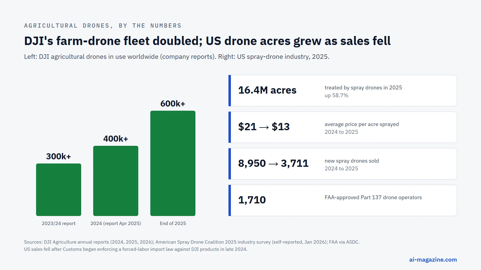
The scale of drone adoption is significant. According to the DJI Agriculture annual report (April 2026, company figures), there are more than 600,000 DJI agricultural drones in use worldwide by the end of 2025, in more than 100 countries. They are operated by more than 600,000 trained pilots, on more than 300 crop types. DJI estimates about 410 million tonnes of water saved and 51 million tonnes of CO2 emissions avoided compared with conventional methods. Spot spraying cuts herbicide use by up to 35%. A year earlier, DJI reported 400,000 drones, showing rapid growth.
China is the largest single market. According to Xinhua, there were 251,000 drones dedicated to agricultural services in 2024. China’s agriculture ministry said in March 2026 that more than 300,000 agricultural drones were in operation. China’s top rural policy document for 2026 called for wider use of drones, IoT, and robots in farming for the first time.
In the US, adoption is growing but faces regulatory and market hurdles. According to the American Spray Drone Coalition industry survey (January 2026, self-reported by operators), spray drones treated over 16.4 million acres in the US in 2025, up 58.7%. The average price per acre sprayed fell 38%, from $21 to $13. However, new spray drone sales fell from about 8,950 in 2024 to about 3,711 in 2025 after US Customs began enforcing a forced-labor import law against DJI products in late 2024. According to AgFunder News (February 2026), Chinese-made drones make up more than 90% of US agricultural spray drones.
Drone spraying in the US: rules and cost per acre
Spraying with a drone in the US requires specific certifications. It requires a Part 137 agricultural aircraft operator certificate, a Part 107 remote pilot certificate, and, for most spray drones (over 55 lb), an FAA exemption under Section 44807. According to the FAA (reported 2025), 1,710 Part 137 drone operators are approved.
In February 2024, the FAA granted Hylio an exemption to fly up to three heavy spray drones at once with one pilot, described as the first approval of its kind in the US. This “swarm” capability increases efficiency by allowing one pilot to manage multiple drones simultaneously.
A new rule for beyond-visual-line-of-sight drone operations (Part 108) was under White House review in 2026 and is not yet in effect. Until it is, pilots must generally keep drones in visual line of sight.
The cost of drone spraying has dropped significantly. According to the American Spray Drone Coalition, the average price fell from $21 to $13 per acre. That is a self-reported industry average; actual prices depend on field size, terrain, crop and product. Whether a drone beats a ground sprayer on a given field is covered in “When drones make sense” above.
The DJI question in the US
DJI’s status in the US market has shifted due to regulatory actions. On 22 December 2025, the FCC added foreign-made drones and critical components, including DJI and Autel equipment named in the 2025 defense authorization act, to its Covered List. This blocks new equipment authorizations. In January 2026, it exempted drones on the Pentagon’s Blue UAS list and domestic products until 1 January 2027.
Drones already purchased can still be used. DJI has challenged the decision; as of October 2026, no court has ruled on the merits. For farmers, this means existing equipment is safe, but buying new DJI drones may become more difficult or expensive if authorizations are delayed.
Drone spraying in Europe
In the EU, aerial spraying of pesticides has been banned under Directive 2009/128/EC, with limited derogations. In December 2025, the European Commission proposed letting member states allow drone spraying for drone types assessed as posing lower or equal risks compared with ground equipment. EU governments adopted their position in May 2026 (pesticides must be explicitly authorised for drone use; EFSA to write the risk guidance). Negotiations with the European Parliament continue; it is not yet law.
Limits of agricultural drones
Drones are not a universal solution. They face several limits. Drift is a known risk, especially in windy conditions, and can affect application accuracy. Payload is limited by battery capacity; larger tanks require more energy to lift, reducing flight time. Battery swaps and refilling are necessary for large fields, which can interrupt workflow. Weather conditions like rain or high humidity can affect spray performance. Operator certification is required, and training is necessary to handle complex flight paths and spray patterns.
Satellites and yield prediction
Satellites provide a broad view of crop health over large areas. The ESA Sentinel-2 offers free imagery with 13 spectral bands and up to 10-metre resolution, revisiting each location about every 5 days at the equator. A third satellite, Sentinel-2C, launched in September 2024, enhancing coverage.
Planet provides near-daily imagery at 3–5 metres and higher-resolution 0.5-metre tasking. This frequent data allows farmers to track changes in crop health in near real-time.
NASA Harvest, launched in 2017 and led by the University of Maryland, is NASA’s contribution to the GEOGLAM global crop-monitoring effort. The GEOGLAM Crop Monitor uses vegetation indices such as NDVI to flag regions where yields look poor or are failing. This data is crucial for early warning systems and supply chain planning.
Robots and autonomous machines
Robots are moving from concept to field. John Deere unveiled a fully autonomous 8R tractor at CES in January 2022, using six pairs of stereo cameras. In 2026, Deere sells autonomy as an upgrade kit for tillage, starting with field cultivators. The tractor can work a field without an operator in the cab while the farmer monitors it remotely.
Tevel, an Israeli company, has developed flying fruit-picking robots tethered to a ground unit. In orange orchard pilots in Brazil (reported June 2026), one robot picked a fruit about every 12 seconds, with six drones per system able to run around the clock. This technology addresses labor shortages in delicate harvesting tasks.
Lely, a leader in milking robots, reported 2025 revenue of €1,014 million, up 18%. Automated milking systems let cows be milked when they choose to visit the robot, rather than at fixed times, and remove a twice-daily manual task.
AI for livestock
AI is transforming livestock management. Halter, a New Zealand company, makes solar-powered GPS cow collars for virtual fencing and herd monitoring. According to the company, it raised $220 million at a $2 billion valuation in March 2026 and says it has sold 1 million collars to more than 2,000 farmers in New Zealand, Australia, and the US. These collars track location, activity, and health indicators, allowing farmers to monitor herds remotely.
A 2025 peer-reviewed study in the Journal of Dairy Science tested a fully automated camera system for detecting lameness in dairy cows on 11 UK farms (more than 40,000 paired scores). The system performed comparably to trained human assessors. Systems like this are designed to flag lame cows without a person scoring every animal by eye.
Generative AI advisers for farmers
Generative AI is providing personalized advice to farmers. Digital Green’s FarmerChat has more than 1 million users in India, Kenya, Ethiopia, Nigeria, and Brazil. According to an independent 60 Decibels study, 70% of users applied the advice within 30 days. This tool uses natural language processing to answer questions in local languages, making AI accessible to farmers who may not be tech-savvy.
Wadhwani AI’s Krishi Saathi in India has more than 1 million farmers by January 2026. It is integrated into the government Kisan Call Centre, working in 11 Indian languages. These tools democratize access to agronomic expertise, bridging the gap between research and practice.
Market size and barriers
The market for AI in agriculture is growing. According to BCC Research (paid report, January 2026), the AI-in-agriculture market is estimated at $2.8 billion in 2025, growing to $8.5 billion by 2030.
However, barriers remain. Connectivity is a major issue. According to the FCC (August 2026), 100/20 Mbps fixed broadband reached 86.7% of rural Americans versus 99.5% in urban areas (June 2025). Globally, the ITU (2025) reports that 58% of rural people use the internet versus 85% in cities; in low-income countries, only 14% of rural people are online. This digital divide limits the adoption of cloud-based AI tools.
Data ownership is another concern. The 2014 Privacy and Security Principles for Farm Data, led by the American Farm Bureau Federation and signed by major ag-tech companies, state that farmers own the information generated on their operations. However, the terms of service of many platforms can be complex, and farmers need to understand who can use their data.
Right to repair is also a key issue. The US Federal Trade Commission sued Deere in January 2025. On 8 July 2026, the FTC and five states announced a settlement requiring Deere to give farmers and independent repair shops access to the same repair tools and software as its dealers for 10 years, pending court approval.
How a farm can start with AI
Starting with AI in agriculture does not require a massive investment. Here are practical steps:
- Start with mapping: Use a drone or satellite data to map your fields. This provides a baseline of crop health and variability. Many services offer this as a one-time or seasonal service.
- Try a spray-drone service: Instead of buying a drone, hire a service to spray a test field. This allows you to see the results and compare costs with ground spraying. Measure savings on herbicide and fuel.
- Check data terms: Before subscribing to any AI platform, read the data ownership and usage terms. Ensure you retain control of your field data.
- Check local drone rules: Understand the regulations in your area, such as Part 137 or Part 107 requirements, and any local restrictions on drone use.
- Invest in connectivity: If you are planning to use cloud-based AI tools, ensure you have reliable internet access. Consider satellite internet if fixed broadband is unavailable.
- Start small: Begin with one field or one crop. Learn the technology, troubleshoot issues, and scale up as you become comfortable.
Frequently asked questions
How is AI used in agriculture?
AI is used in agriculture for precision spraying, where cameras identify weeds and trigger targeted herbicide application. It is used in drones for mapping and spraying, in satellites for yield prediction, in robots for harvesting and tillage, and in livestock management for health monitoring. AI helps farmers make data-driven decisions, reducing input costs and improving yields.
Are agricultural spray drones legal in the US?
Yes, but they require specific certifications. Spraying with a drone requires a Part 137 agricultural aircraft operator certificate, a Part 107 remote pilot certificate, and, for most spray drones (over 55 lb), an FAA exemption under Section 44807. As of 2026, there are over 1,700 approved Part 137 operators.
How much does drone spraying cost per acre?
According to the American Spray Drone Coalition (January 2026), the average price per acre sprayed by drones in the US fell to $13 in 2025, down from $21 in 2024. This is a self-reported industry average; prices vary with field size, terrain, crop and product.
Can drones spray pesticides in the EU?
Not yet universally. The EU banned aerial spraying of pesticides under Directive 2009/128/EC, with limited derogations. In December 2025, the European Commission proposed allowing member states to permit drone spraying for low-risk drone types. EU governments agreed their position in May 2026; talks with the European Parliament continue, so it is not yet law.
Will AI replace farmers?
No. AI is a tool that augments human decision-making. It handles repetitive tasks, processes large datasets, and provides insights, but it does not replace the farmer’s judgment, experience, and adaptability to local conditions. AI helps farmers work more efficiently, not disappear.